The India Meteorological Department said the system may intensify into a Bay of Bengal cyclone storm by Monday and hit near Kakinada by Tuesday night.
Bay of Bengal Cyclone Likely To Form On Monday
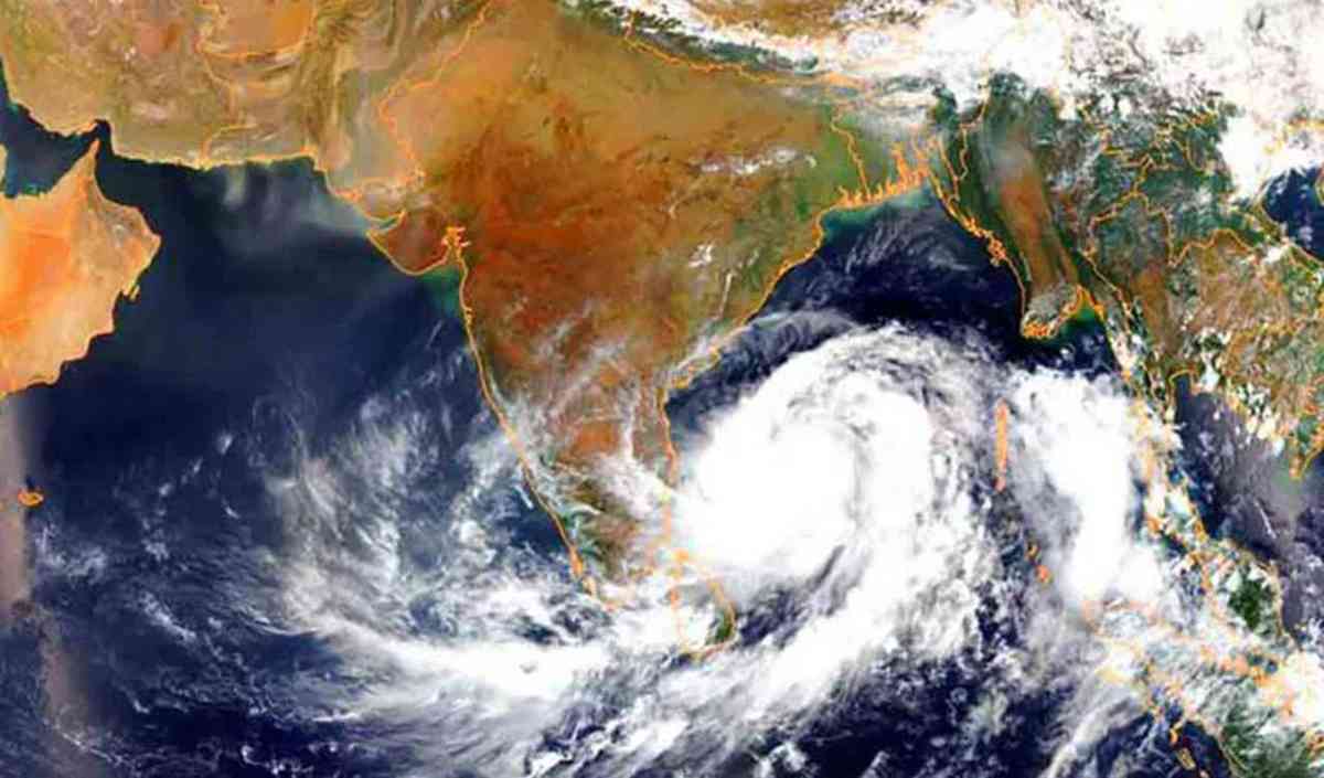
The India Meteorological Department (IMD) on Saturday warned that a Bay of Bengal cyclone is likely to form early next week. The depression over the southeast Bay of Bengal has moved westward and is expected to strengthen into a deep depression by Sunday (October 26) and a cyclonic storm by Monday morning.
According to IMD officials, the system will intensify over the southwest and adjoining west-central Bay of Bengal and is likely to make landfall near Kakinada, Andhra Pradesh, by Tuesday night.
The cyclone is expected to bring maximum wind speeds of 90–100 kmph, with gusts reaching up to 110 kmph, the weather office said.
States On Alert As Bay of Bengal Cyclone Intensifies
Authorities in coastal states have been placed on high alert as the Bay of Bengal cyclone gathers strength. The IMD has advised fishermen not to venture into the sea for the next three days.

Heavy rainfall is likely over north coastal Andhra Pradesh, southern Odisha, and parts of Tamil Nadu and Puducherry. Wind speeds will gradually increase along the coast from Sunday evening.
Local administrations have started evacuation drills in low-lying areas, especially near Nellore, Kakinada, and Machilipatnam. The National Disaster Response Force (NDRF) and State Disaster Response teams are on standby.
Cabinet Secretary Reviews Preparedness
Cabinet Secretary T.V. Somanathan chaired a meeting of the National Crisis Management Committee (NCMC) on Saturday to review preparedness for the Bay of Bengal cyclone.

Top officials from the Ministry of Home Affairs, Defence, Power, and Telecommunications joined the review meeting. The Chief Secretaries of Tamil Nadu, Andhra Pradesh, and Puducherry, along with the Additional Chief Secretary of Odisha, shared updates on evacuation plans and relief readiness.
The Cabinet Secretary directed all departments to ensure uninterrupted power, communication, and emergency services in cyclone-hit areas. He also instructed that rescue teams be pre-positioned before the landfall.
IMD Issues Early Warning For Fishermen
The IMD said the sea condition over the Bay of Bengal is likely to become “very rough to high” from Sunday onward. Fishermen have been warned to avoid deep-sea areas until the system weakens.
“The depression will intensify into a cyclonic storm by Monday morning and move toward the north Andhra Pradesh coast. People should stay alert and follow official advisories,” the IMD said in its bulletin.
Officials also expect tidal surges of one to two meters along parts of the Andhra coast during landfall.
Preparedness In Full Swing
Relief shelters have been set up in vulnerable coastal districts, and emergency stocks of food, water, and medicine are being mobilized. The Indian Navy and Coast Guard have deployed ships and aircraft for surveillance and possible rescue operations.
Authorities are also monitoring water levels in rivers and reservoirs to prevent flooding. District collectors have been instructed to ensure quick communication between disaster response teams and local authorities.
Cyclone Expected To Hit Kakinada By Tuesday Night
If current forecasts hold, the Bay of Bengal cyclone will make landfall near Kakinada late Tuesday, bringing strong winds and heavy rain. IMD said it will continue to issue regular updates and track the storm’s intensity and path.
Residents along the Andhra Pradesh and Odisha coasts have been urged to remain indoors during landfall and avoid unnecessary travel.

Tanisha Singh writes for Hindi News 99, covering India news and technology with accurate and engaging updates.